| [ Login ]/[ Register ] |
 Search ::
  My Data Basket ::
  Favorite/My Favorite :: Recent Changes :: :: Login Save in Data Basket ]
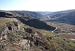
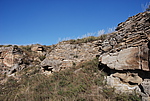
| Caption:杨石畔山险墙 Photo Time:2007-10-16 15:34:43 Photo Contributor:陕西省文物局 [Open in New Window] |
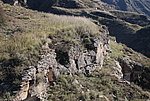
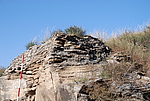
| Caption:杨石畔山险墙 Photo Time:2007-10-16 15:35:15 Photo Contributor:陕西省文物局 [Open in New Window] |
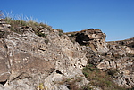
| Caption:杨石畔山险墙 Photo Time:2007-10-16 15:48:18 Photo Contributor:陕西省文物局 [Open in New Window] |
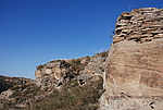
| Caption:杨石畔山险墙 Photo Time:2007-10-16 15:48:26 Photo Contributor:陕西省文物局 [Open in New Window] |
| Caption:杨石畔山险墙 Photo Time:2007-10-16 15:48:39 Photo Contributor:陕西省文物局 [Open in New Window] |
| Caption:杨石畔山险墙 Photo Time:2007-10-16 15:49:19 Photo Contributor:陕西省文物局 [Open in New Window] |